


This article was contributed by retired Earth Science teacher Jim Ostdick.
Looking back in geological time into the Mesozoic Era, the land that makes up San Benito County and the Monterey coast did not exist in present form. There were no Sierra Nevada. There were no coastal mountain ranges. There was no San Benito River valley. There were no sunny beach villages. There was no Monterey Bay. Piece by piece, over millions of years, this is the story of how San Benito County came to be.
One-hundred and fifty million years ago in the Jurassic Period, the edge of the North American Plate was part of an active subduction zone just west of what today is the Great Central Valley. The subduction trench and a part of the ocean crust called the Farallon Plate were covered by deep, cold, salty water. Within the continental crust, large volumes of magma were cooling, later to rise and become the Sierra Nevada.
As time passed, over the next 100 million years, part of the upper Farallon Plate did not sink into the subduction trench. Instead, pieces of the upper plate were “accreted” or stuck to the edge of the continental crust, adding new material to the North American Plate. These altered fragments of the ocean crust are preserved today as part of what we call the Coast Ranges.
The Coast Ranges extend from the Klamath Mountains in northern California to the Transverse Ranges in southern California. One segment of the Coast Ranges is called the Diablo Range, which forms the eastern side of San Benito County. Consisting mostly of remnants of an old volcanic arc plus a mélange of serpentinite and greywacke sandstone of the Franciscan formation, these are the mountains we see at sunrise or when driving east over Pacheco Pass. This ocean crust material also underlies the sediments that form the San Benito River valley.
Roughly 30 million years ago, as the Farallon Plate slowly disappeared into the subduction zone, a corner of the Pacific Plate followed right behind it. The Pacific Plate eventually came into direct contact with the North American Plate, bringing along with it great tectonic changes to the west coast.
As more of the huge Pacific Plate pushed into the North American Plate, about 20 million years ago, the plate boundary was converted from a convergent boundary (head-on collision) to a transform boundary (lateral, side-to-side action). Subduction along this new boundary stopped. Strike-slip motion began. The mighty San Andreas Fault was born.
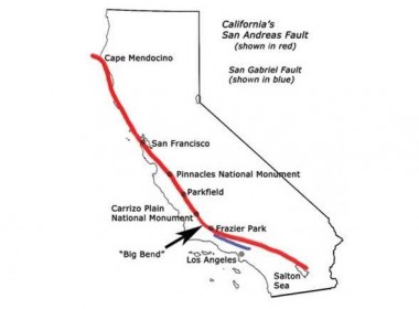
By 10 million years ago, as the Pacific Plate and the North American Plate continued to grind sideways against each other, the San Andreas Fault grew and grew. Parts of the Transverse Ranges slid northwest along the fault. The Gabilan Range slowly made its way from southern California to form the western border of what would eventually become San Benito County. The rocks of what would later be Fremont Peak and The Pinnacles had found their new home.
The San Andreas Fault currently extends from Cape Mendocino north of San Francisco more than 700 miles to the Gulf of California. It is the most famous and the most studied earthquake fault in the world.
By studying the rock record in the context of plate tectonics, geologists have reconstructed the timing and processes of how San Benito County came to be. The story is not over, of course, but the events so far can be summarized as follows.
- The land that makes up San Benito County was formed over the course of the last 150 million years by the forces of plate tectonics.
- The east side was formed by accretion of ocean crust along a convergent boundary.
- The west side was transported here by lateral motion of continental crust along a transform boundary.
That’s it in a nutshell, folks. I hope you have enjoyed this brief six-part series on San Benito geology. If you are a young person reading this series, I encourage you to enter a course of study that will lead you to a profession in one of the many fields of Earth Science. Opportunities for a rewarding career abound, whether it be in education, geology, oceanography, meteorology, climatology, or space science. Go for it! There is much more work to be done.
Other articles in this series:
San Benito Geology: San Benito Underwater
San Benito Geology: Earthquake 101
San Benito Geology: All Your Faults
San Benito Geology: Living on the Edge
San Benito Geology: The Great San Benito ShakeOut
You must be logged in to post a comment.